- Home
- About Us
- Students
- Academics
-
Faculty
- Electrical Engineering
- Automation
- Computer Science & Engineering
- Electronic Engineering
- Instrument Science and Engineering
- Micro-Nano Electronics
- School of Software
- Academy of Information Technology and Electrical Engineering
- School of Cyber Security
- Electrical and Electronic Experimental Teaching Center
- Center for Advanced Electronic Materials and Devices
- Cooperative Medianet Innovation Center
- Alumni
-
Positions
-
Forum
News
- · Shanghai Jiao Tong University professors Lian Yong and Wang Guoxing's team have made remarkable progress in the field of high-efficiency pulse neural network accelerator chips.
- · AI + Urban Science research by AI Institute was selected as cover story in Nature Computational Science!
- · The first time in Asia! IPADS's Microkernel Operating System Research Wins the Best Paper Award at SOSP 2023
- · Delegation from the Institution of Engineering and Technology Visits the School of Electronic Information and Electrical Engineering for Journal Collaboration
- · Associate professor Liangjun Lu and research fellow Jiangbing Du from Shanghai Jiao Tong University made important advancements on large capacity and low power consumption data transmission
AI + Urban Science research by AI Institute was selected as cover story in Nature Computational Science!
Leveraging the AI for Science Data Open Platform at Shanghai Jiao Tong University, Professor Xiaokang Yang and Associate Professor Yanyan Xu from AI Institute, along with Professor Marta Gonzalez from the University of California, Berkeley, have collaborated on AI + Urban Science research, and recently they made significant progress. Their recently published work addresses the challenge of sensing urban dynamics in a quasi-real-time manner. They propose a new indicator, mobility centrality index, from a human behavior perspective, to describe the dynamic evolution of urban functional structures. They apply this mobility indicator to analyze the evolution of urban functional structures during large-scale emergency events such as natural disasters and pandemics. They also validate the potential of this new indicator for predicting urban epidemic trends using machine learning models. This can provide supports for urban decision-making.
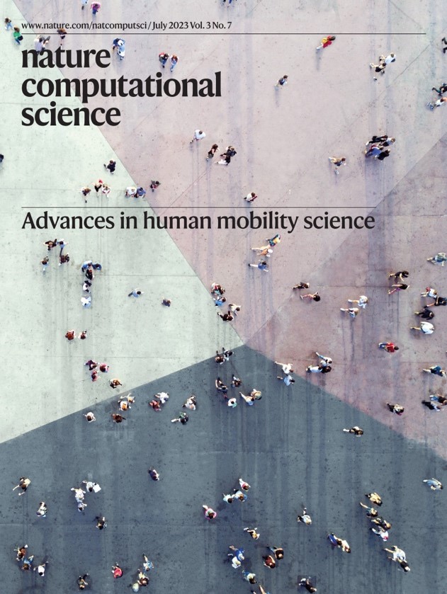
The relevant findings were published under the title "Urban Dynamics Through the Lens of Human Mobility" in Nature Computational Science and were selected as the cover story.
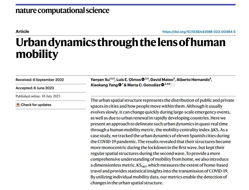
With the development of information communication and intelligent computing technologies, urban science has shifted from macro-level research driven by small-scale survey data to multi-scale quantitative research driven by big data. Increasingly, computer scientists are using artificial intelligence (AI) technologies to study cities as complex systems, forming an emerging interdisciplinary research field known as AI + Urban Science.
The Big Data Intelligence Team at the AI Institute at SJTU focuses on using big trajectory data and generative AI technologies to model and optimize complex urban systems. This study primarily addresses the question: How can we track the evolution of urban functional structures in real-time when cities are affected by large-scale events (such as natural disasters or pandemics) to support scientific decision-making? To tackle this crucial issue, the team utilized trajectory data from 21 cities worldwide and discovered the intrinsic connection between human mobility behaviors and urban structures. They proposed a universal indicator, mobility centrality, to characterize the dynamic structure of cities through mobility behaviors. Using 11 cities in Spain as an example, they tracked changes in urban functional structures in real-time during the pandemic and confirmed the importance of dynamic urban structures and mobility behaviors in predicting the pandemic trends using machine learning models.
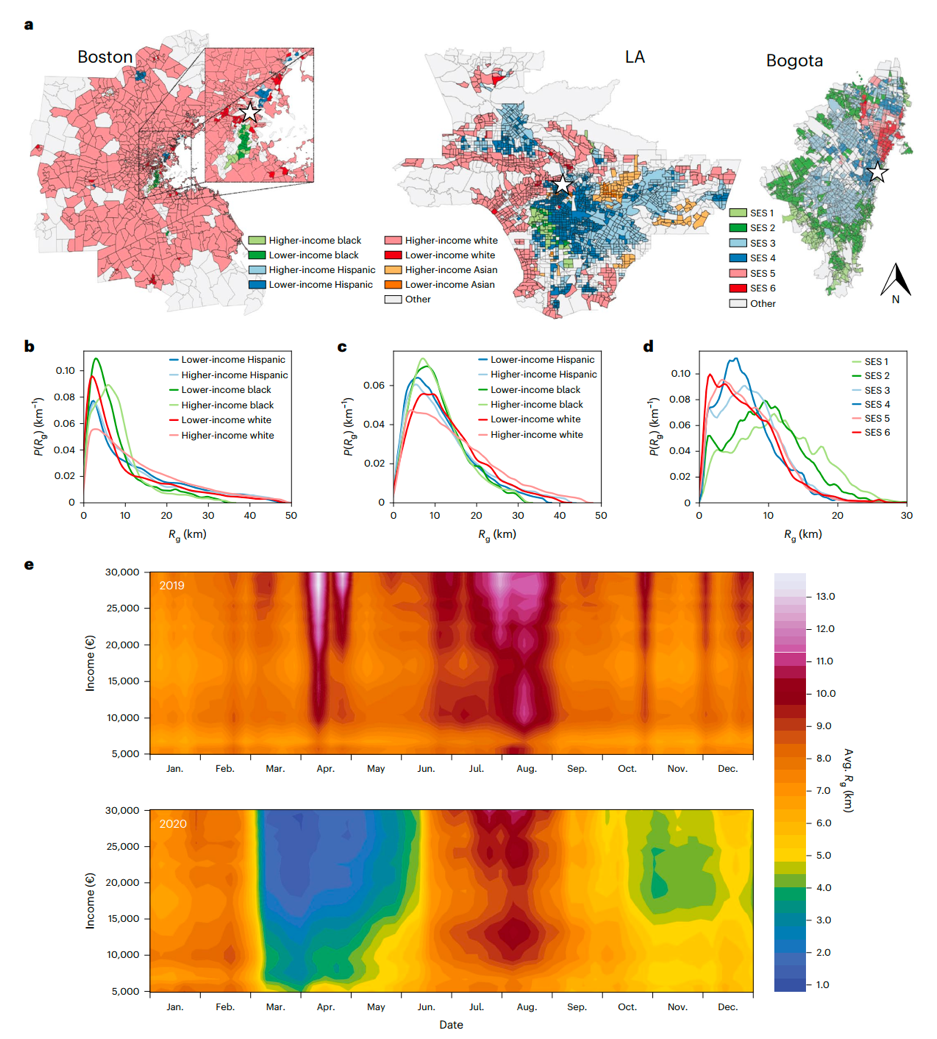
Mobile trajectory big data characterizes urban spatial segregation and the differential impact of the pandemic on human mobility.
To address the challenge of real-time quantification of large-scale urban functional structures that statistical survey data cannot meet, the team explored the interactions between human mobility behaviors and urban spatial structures using mobile trajectory big data. The research revealed diverse relationships between residents' activity radii and their socioeconomic status in different cities. For instance, in Boston, high-income individuals live in the suburbs and travel longer distances, while in Bogotá, high-income individuals live closer to the city center and travel shorter distances.
Moreover, by analyzing the mobile trajectories of 17 million people across Spain from 2019 to 2020, the study uncovered that COVID-19 affected different income groups differently. Lower-income individuals, lacking the opportunity to work from home, had to make more necessary trips during the peak of the pandemic.
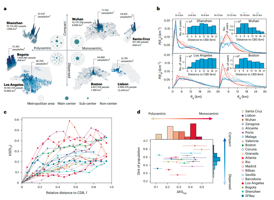
Urban Dynamics from the Lens of Human Mobility
Meanwhile, to achieve real-time descriptions of the dynamic evolution of different urban structures, the paper analyzed individual mobility data from 21 cities worldwide, including Shenzhen and Wuhan. The findings showed that in monocentric cities like Wuhan, the distance between residents' homes and the Central Business District (CBD) significantly influences their activity radius (Rg). In contrast, in polycentric cities like Shenzhen, this influence is relatively minor. Based on this observation, the study divided cities into several concentric rings centered around the CBD. By comparing the probability distribution of Rg within each ring to that of the innermost ring (the CBD ring) using the Kolmogorov-Smirnov (KS) statistic, the researchers proposed a universal indicator to quantify the mobility differences among different areas—mobility centrality (∆KS). A larger ∆KS indicates that people's mobility range rapidly increases with distance from the CBD, suggesting a more monocentric urban structure. Conversely, a smaller ∆KS implies a tendency toward a polycentric structure.
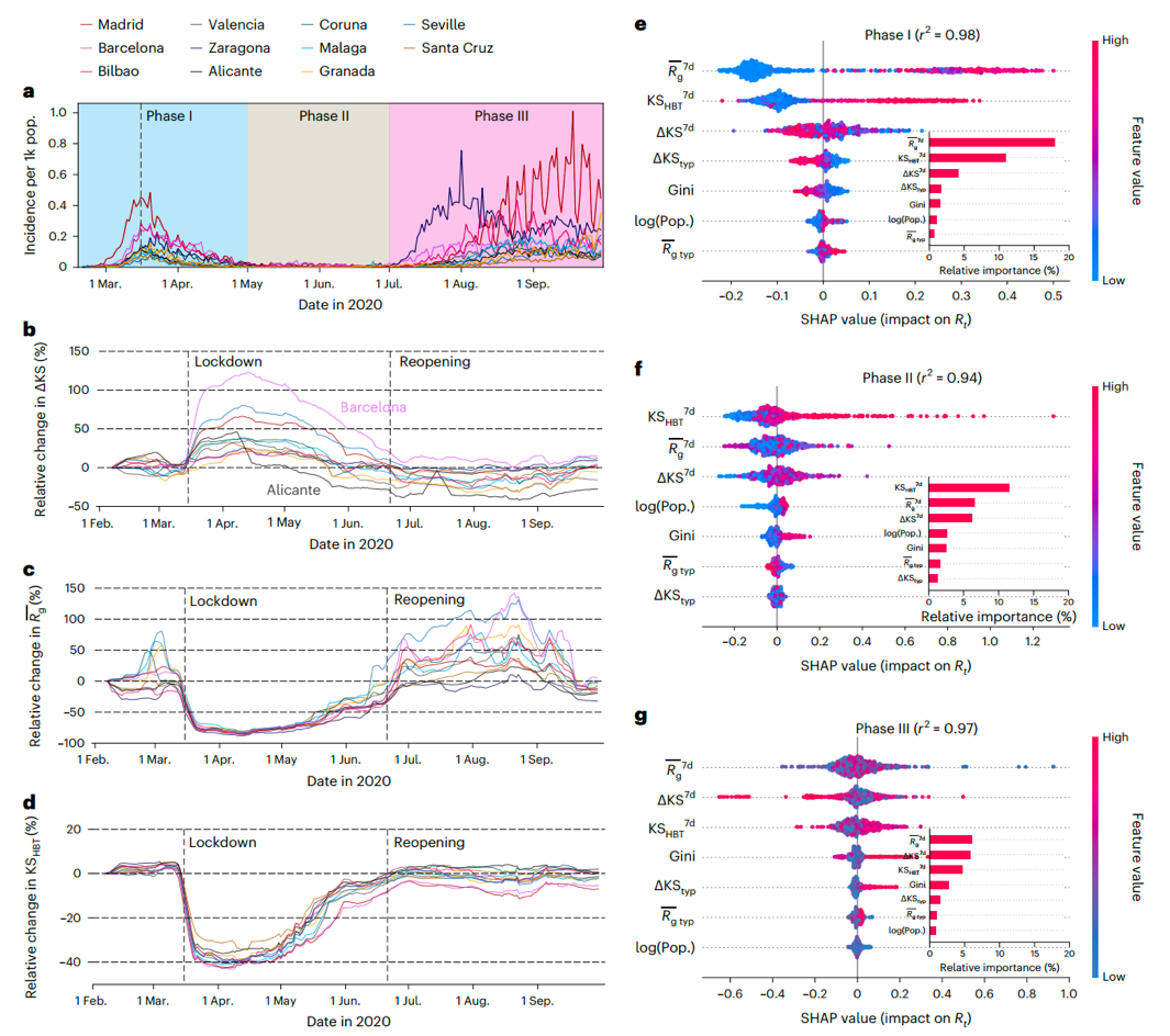
Using machine learning to evaluate the importance of urban structure in pandemic prediction models.
To track the dynamic changes in urban functional structures during major events such as natural disasters and pandemics, the paper took 11 cities in Spain as an example. The study found that during the COVID-19 period, most cities experienced a contraction in their structures, further confirming the unequal impact of the pandemic on human behavior. Specifically, the activity restrictions during the pandemic had a greater impact on suburban residents compared to urban residents. They needed to travel longer distances to obtain essential resources compared to those in urban areas. Building upon this observation, the team conducted empirical research on how stay-at-home orders affected residents' mobility activities. They proposed a residential-based mobility range indicator, KS_HBT, and used machine learning to model the pandemic trends in the 11 cities. The study confirmed that the mobility centrality indicator (∆KS) proposed in the paper, along with the quantified mobility range indicator KS_HBT, could effectively capture the dynamic evolution characteristics of cities, assisting in pandemic trend prediction.
In this study, the quantification of dynamic functional structures in complex urban systems was addressed. By integrating data science and statistical physics methods, the research innovatively used human mobility behavior as a lens to perceive near-real-time changes in urban spatial structures. This approach can be applied to track rapid urban updates and changes in urban functionality during major events. It provides crucial urban features for subsequent artificial intelligence simulations of complex urban systems, supporting decision-making in urban science.
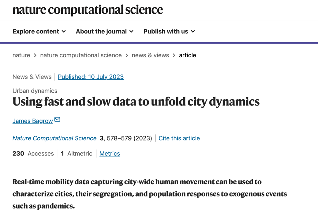
Given the novelty and significance of this achievement, Nature Computational Science invited Professor James Bagrow from the Department of Mathematics and Statistics at the University of Vermont to provide an in-depth analysis and commentary on the paper in the same issue. Professor Bagrow's review highlighted the effective integration of statistical survey data with mobility behavior data, successfully applied to describe urban functional structures and the impact of major events such as pandemics on resident behavior.
About Nature Computational Science:
Nature Computational Science is a top-tier academic journal in the field of computational science, published by the internationally renowned scientific journal "Nature." It is dedicated to publishing peer-reviewed interdisciplinary research based on computational technology, aiming to use computational science in novel ways to discover new insights and solve challenging real-world problems. The journal covers high-quality research results from various computational science fields, including computational methods, data science, artificial intelligence, and AI for Science.
About the publication:
Shanghai Jiao Tong University is the primary institution for the paper, with Associate Professor Yanyan Xu from the Artificial Intelligence Institute as the first author and Professor Xiaokang Yang as a co-author. Professor Marta Gonzalez from the University of California, Berkeley, serves as the corresponding author for the paper. The research received support from the Shanghai Municipal Major Project for Artificial Intelligence and the AI for Science Scientific Data Open Source Platform at Shanghai Jiao Tong University.
Please refer to the paper for more information: https://www.nature.com/articles/s43588-023-00484-5
-
Students
-
Faculty/Staff
-
Alumni
-
Vistors
-
Quick Links
